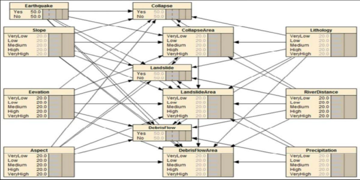
The earthquakes and other natural disasters causing effects on ecosystems and the environment are gaining more courtesy worldwide. The development of uncertainty reasoning models allows for investigating these complex relationships i.e landslides, debris flow and collapse. The Bayesian Network model and ARCGIS software are combined to construct a disaster chain hazard assessment model. Hazards zoning maps are produced using ARCGIS, whereas the Bayesian Network model is used to conclude the hazard intensity and probability of the disaster chain hazards. Error rate and the scoring rule measure the Bayesian Network model's performance. The results show that the AUC value is 0.88, which indicates the good predictive performance of the model. The very high hazard zones are primarily determined inside the 8-km radius of Gilgit and Attabad, the high hazard zones are located in the southwestern region of the researched area, whereas the northern and eastern parts of the observed area primarily
Project Overview:
Bayesian networks (BNs) are an increasingly popular method of modelling uncertain and complex domains such as ecosystems and environmental management. At best, they provide a robust and mathematically coherent framework for the analysis of this kind of problems. Bayesian Network, despite being a popular and effective method for statistical analysis in the field of environmental management, has never been use in Pakistan to address Hazard assessments. This model may prove very helpful for the policy makers and researchers to develop sustainable and efficient policies for land use, Disaster management, Town Planning, Road mapping and other environmental issues.
Objectives:
1. Earthquake Hazard Data collection
2. Bayesian Model Development
3. Increase in the overall accuracy of model
4. Earthquake Hazard Assessment of KKH Gilgit to Khunjerab
Benefits:
- Town Planning
- Road Mapping
- Disaster Management
Methodology:
Methodology is divided into 3 steps
- Data Acquisition
- Model Development
- Validation
Data Acquisition: Data is collected through ARCGIS and attribute values are extracted
Model Development: Bayesian Network and hazard Assessment model is developed
Validation: after getting the results from the models they are validated through ROC Curve and SCAI
Conclusion:
1. The seismic earthquake disaster chain hazard model is presented in which hazard intensity and chain probability are determined by the Bayesian Network model. ?
2. ArcGIS produce earthquake disaster chain maps. ?
3. The exceptionally high hazard zones are mainly concentrated inside the 8-km radius focus on Gilgit and Attabad. ?
4. The high hazard zones are located in the southwestern region of the researched area. ?
5. The regions with medium danger levels are strewn across the entire study area.
6. The northern and eastern parts of the examined area mainly exhibit extremely low-to-low hazard values.