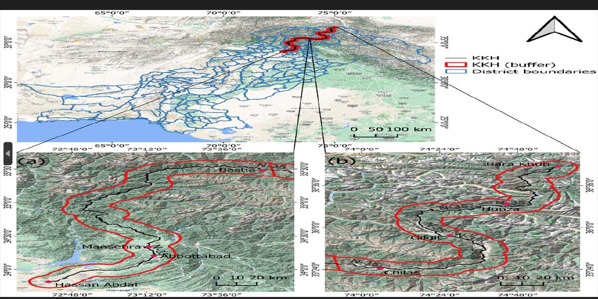
The Karakoram Highway is a pathway of CPEC that provides important economic and social services to human communities, including trade exchange, transportation facilities, cultural exchange, and the flow of materials, but can also have a significant impact on the environment, including vegetation, moisture contents, and surface temperature. This study's main aim was to conduct an EQI assessment based on the Normalized Difference Vegetation Index (NDVI), Normalized Difference Moisture Index (NDMI), and Land Surface Temperature (LST) to analyze the environmental effects of building the Karakoram Highway (KKH), which extends from Hasan Abdal in the Punjab province to Bara Khun in Gilgit-Baltistan, by concentrating on a 20 km buffer zone (10 km on either side of the highway). Through utilization of cutting-edge remote sensing techniques and analyzing a number of remote sensing photos taken at various time intervals, we were able to obtain a deeper understanding of the spatial and temporal effects of the KKH
Objectives
The objective of this study is to evaluate and comprehend the spatial and temporal repercussions of the construction of the Karakoram Highway (KKH) on the environment and the processes of ecological recovery. To achieve this, remote sensing techniques and data will be employed to measure and track the environmental impacts resulting from the construction activities along the KKH. Furthermore, an analysis of land use and land cover (LULC) changes caused by the construction of the highway will be conducted to gain insights into transformations in land patterns and to assess the effects on ecosystems, habitats, and human settlements. In order to provide a comprehensive assessment of the impacts, the Environmental Quality Index (EQI) will be utilized to evaluate the overall environmental condition.
Socio-Economic Benefit
The construction of the Karakoram Highway in the northern region of Pakistan has prompted the need for an enhanced understanding of its environmental impacts. Through the quantification of land cover changes and vegetation dynamics, valuable insights can be gained to aid in environmental management and conservation efforts. This knowledge will inform environmentally sensitive infrastructure planning by mitigating adverse effects on ecosystems and human settlements. Additionally, it will guide effective land-use planning and resource allocation, promoting sustainable development in the region. Furthermore, by raising awareness among policymakers, stakeholders, and the public about the significance of considering environmental impacts in infrastructure projects, a more environmentally conscious approach can be fostered.
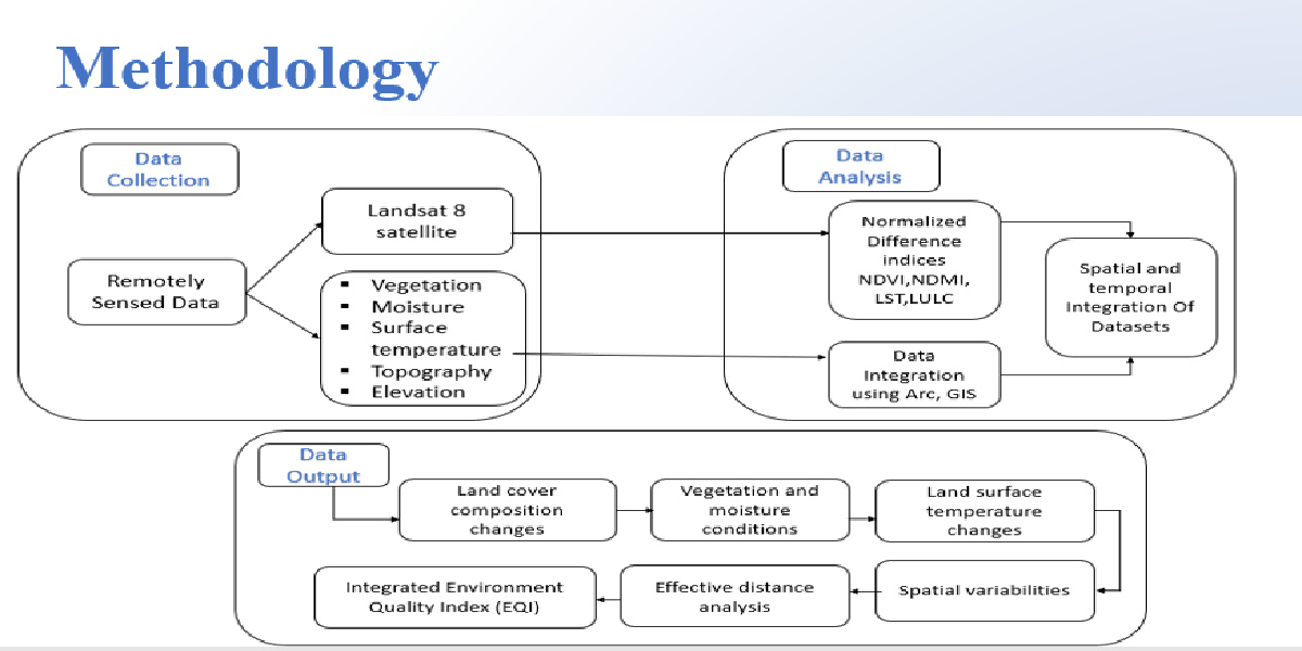
Methodologies
The methodology employed in this study involved the utilization of Landsat 8 satellite imagery and ArcGIS software for data collection and analysis. Landsat 8 imagery was selected due to its high spatial resolution and multispectral capabilities, enabling the assessment of various environmental parameters. The collected satellite data was processed and analyzed using ArcGIS, a powerful geographic information system (GIS) software. Several derived maps were generated, including Land Use/Land Cover (LULC), Normalized Difference Vegetation Index (NDVI), Normalized Difference Moisture Index (NDMI), Land Surface Temperature (LST), and Digital Elevation Model (DEM). These maps provided valuable insights into land cover changes, vegetation dynamics, moisture levels, surface temperatures, and topographical features. By employing this methodology, a comprehensive understanding of the environmental impacts of Karakoram Highway construction in the northern region of Pakistan was achieved.
Outcome
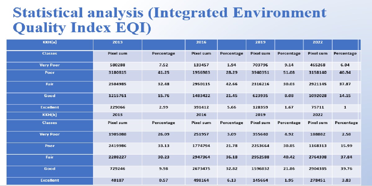
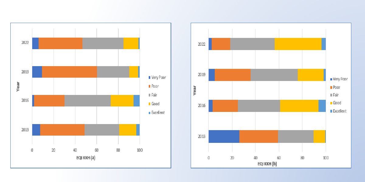
The assessment of the environmental impacts of Karakoram Highway construction in the northern region of Pakistan was effectively conducted using remote sensing techniques. By employing parameters such as Normalized Difference Moisture Index (NDMI), Normalized Difference Vegetation Index (NDVI), Digital Elevation Model (DEM), Land Surface Temperature (LST), and Environmental Quality Index (EQI), a comprehensive understanding of the environmental condition resulting from the construction was achieved. The study revealed clear degradation and recovery trends in vegetation, moisture conditions, and surface temperatures, which corresponded to the different phases of construction and operation. These findings serve as a practical tool for policymakers and researchers, providing them with an effective means to evaluate and address the environmental concerns associated with Karakoram Highway construction.